
Class prepares storm spotters
vere weather preparedness during a storm spotter class Wednesday evening at Fort Scott Community College.
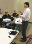
Representatives of Bourbon County Emergency Management, city and rural fire departments and other first responders attended the class, which took place in the Danny and Willa Ellis Family Fine Arts Center on the FSCC campus. Steve Runnels with the National Weather Service office in Springfield, Mo., led the class.
Discussion took place on several topics related to severe weather, such as safety, communications and use of social media to inform the public of severe weather events.
Bourbon County Emergency Manager William Wallis said 32 people attended the class, which is an annual training event for first responders. He said the class is also timely as the county has already experienced a couple bouts of severe weather this year.
"It was great class participation," Wallis said. "I believe a lot of people walked away with a lot of good information."
The class consisted primarily of area first responders and "some citizens," Wallis said.
"It's used to bring people up to speed on the latest and greatest technology if it's available," he said. "It's a good safety training for storm spotters."
Other topics of the discussion included tactical readiness and response, situational awareness, response, and accuracy of reporting a storm system. Wallis said responders learn "what a system is and what to look for."
"Things like rain, rotation and debris," he said. "And then the steps after that. Where do you go from there?"
According to information presented at the class, situational awareness includes storm watches and warnings and use of radar. Response includes spotter deployment, communications and analysis. Accuracy of reporting includes what is witnessed as part of the storm, distance and elements of the storm.
"With reporting, a lot of first responders understand specific things," Wallis said. "It's about making a conglomerate networking event. Everybody is a partner and we're spread out."
Runnels talked about using social media to communicate severe weather events and making sure information that is reported is accurate. He said various types of social media are becoming more commonly used to warn people of weather emergencies.
In response to questions from the class about comparisons between different sources of weather information, Runnels said many people get updates from local television stations or major networks such as The Weather Channel. He said the information relayed in either case is usually similar.
Wallis said the two-hour training class was the proper length to take in valuable information but not so long as to overwhelm participants.
There was also some talk at the class about promoting different applications and systems, such as CodeRed, that communicate weather events. CodeRed is an application for mobile devices that alerts the public to severe weather emergencies.
"I reached out to some people who are not signed up," he said.
Wallis said there are "multiple lines of communication" that people can use to get information on weather events. Along with CodeRed, other common forms of communication include television, scanners and weather radios, the latter of which Wallis said should be "property tuned and programmed."
"These are things people need if they can have these items and fit them into their budgets," he said.
Wallis sand he and Deputy Emergency Manager Shane Walker are also looking at the possibility of "tapping into" the use of Ham radios for communication purposes.
"It's a good backup system and a form of communication that makes sense," he said. "Ham radio operators are relaying information on storms that are headed towards a county ... it gives you a heads up.
"We're looking at getting someone established in this office being able to obtain some information and see how good it is," he said.
According to information presented at the class, storm spotters should observe the following safety tips for a supercell:
* Identify the updraft and downdraft and apply the right hand and windshield rule. Remain at least three miles away.
* Determine storm motion and be ready for changes.
* Ensure safety, identify escape routes.
* Look for visible rotation in updraft.
* Watch rain free base for wall cloud and/or tornado development.
For a squall line:
* Identify the shelf cloud extending across horizon and anticipate damaging wind along leading edge. Check your location for potential falling objects and position car safely.
* Watch for short-lived tornadoes.
The following also applies for storm spotters to spot storms safely: Set expectations, be ready to adjust and be willing to escape to shelter.
* Maintain two-way communication with department dispatch or net control; receive/apply information in warnings, follow up statements and reports; monitor radar or hear updates; apply windshield test, right hand rule and stay three to five miles away from the storm.